Greetings from finishers of the Belmont County EXPLORE MORE GeoTour!
Relaunched June 12th, ShelleyJean and I found ourselves bobbing along US Route 40, aka the Historic National Road, beginning in Springfield, Ohio and heading East to Martins Ferry.
"The National Road was the first federally planned and funded interstate highway. Crossing 6 states (Maryland, Pennsylvania, West Virginia, Ohio, Indiana and Illinois), the road linked older eastern communities with the emerging frontier settlements of the Northwest Territory. In a generation of use, the populations of Ohio, Indiana, and Illinois grew from 783,635 to over 3.72 million people." [Touring Ohio]
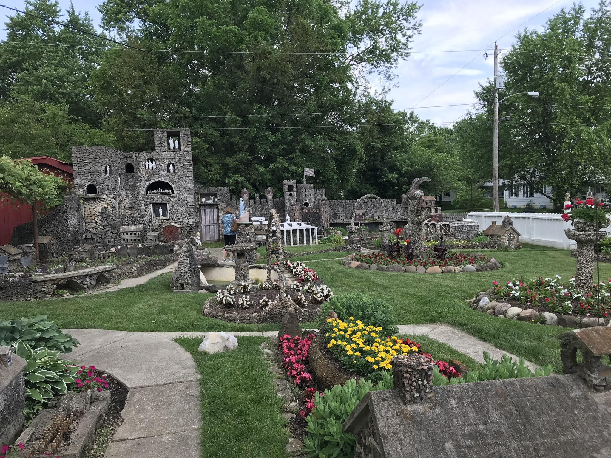
"In 1932, H.G. "Ben" Hartman was working in his year, building a stone-lined fish pond when he became inspired. Unemployed during the Great Depression, Hartman used his time to build a sprawling rock wonderland in his yard."
With this fun little fantasyland as our start, we intrepid explorers were excited to travel along the Historic road, grabbing special caches while working on our Ohio counties. This, however, was almost derailed when we pulled into a cemetery near Columbus and were surrounded by the locals. Not zombies. Cicadas. OH MY GOD!
They were everywhere! Lining fences, perched on weeds, crunching underfoot, crawling on me. As ShelleyJean said, the trees are moving (and it wasn't the wind!). Plus the sound was deafening! It is not an experience one can describe, but be grateful if you never have to experience it.
 |
| Photo by ShelleyJean |
These creepy critters didn't completely deter us from visiting cemeteries, but we didn't linger either.
 |
| Jack's Cache |
If you've followed this blog, you know our fascination with Roadside America, and the
Longaberger basket, near Newark, definitely qualifies! I've even started a
bookmark list with some of our favorites (still under construction). Rumor had it that the Longaberger basket would be saved and developed into a hotel, but the deal fell through earlier this year. Sad. If you look up close you can see it's showing its age. Afterwards, we moseyed down to Longaberger's Heritage Village to photograph a giant basket of apples.
Last stop of the night, up one of the most secluded curving roads outside St Clairsville, is one of the saddest Virtuals I've experienced. Located on a beautiful hill is the site where 13 year-old Louiza Catharine Fox was murdered in 1869.
It is located next to the Egypt Valley Wildlife Refuge and accessed via winding dirt roads leading up a mountain, Its a beautiful site with an amazing view, but who takes care of it? Who maintains the grave area all these years later? The area is populated by many wild bunnies and singing birds.
One of the stops in the GeoTour is nearby
Salem Cemetery, where several days later we found and paid our respects at Louiza's grave. Hopalong Cassidy's birthplace is at the foot of the mountain.
 |
| N 040° 05.368' W 081° 09.227' |
And these National Road markers were the last of our roadside kitsch for the night. We eventually found around 6 of the remaining 83 mile makers still in existence. Each one, located on the North side of the road and set a mile apart, advised travelers how far they've travelled from Cumberland, MD.
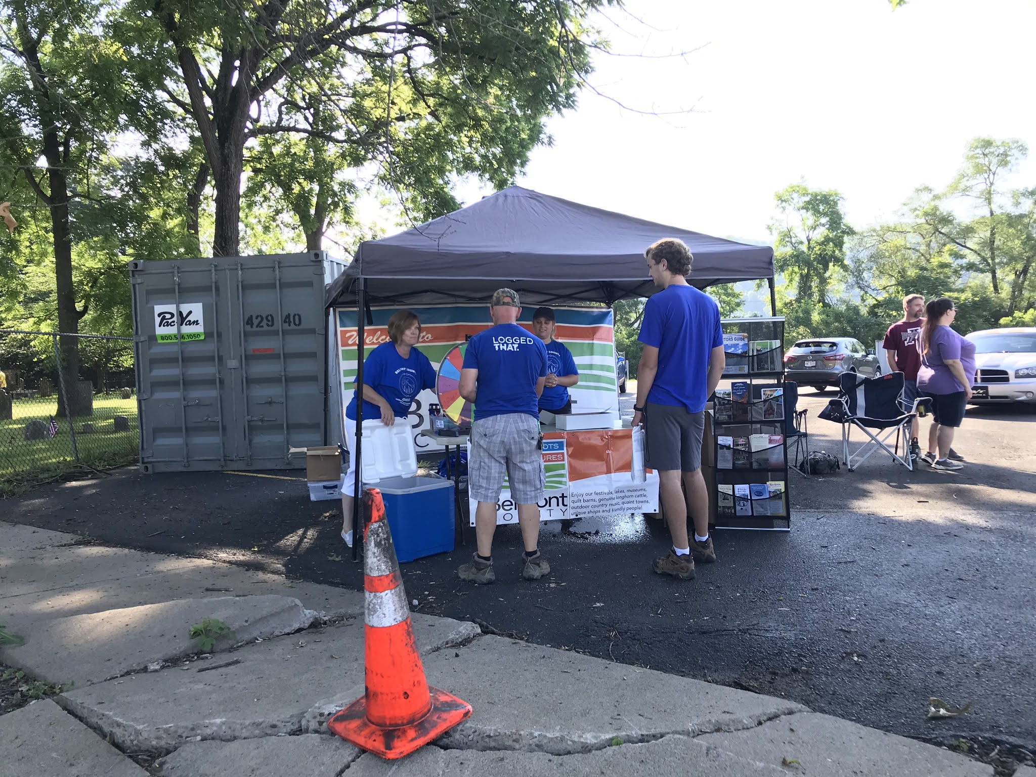
Belmont County Explore More GeoTour Kick-off
The people of the Belmont County Tourism Council were the nicest people! They greeted us at the kick-off event in Martin's Ferry with goodie bags, sweet treats, and spin-the-wheel for prizes. I won a really nice cooler, which TaGeez promptly stole when I returned home.
This sweet boy is Jersey. He is an emotional support dog that sits with abused children while they testify against their parents in court. His owner is a geo-daddy, and Jersey is
trackable. He's will be at Midwest GeoBash this year, too.
9 a.m. hit, and 35 GeoTour caches published. Aha! The first one was within a hundred feet of the kickoff in
Walnut Grove Cemetery. This seemed like an auspicious start to the tour!
 |
| Scrapcat is FTF post-publication |
Belmont County offered a wide variety of historical sites. ShelleyJean and I setoff with the grouping aligning the Ohio River, separating Ohio from West Virginia. Cemeteries with amazing views, historic sites along the National Road, boxes hidden down birding trails, but...
No cache at the
Unofficial Lego Toy and Plastic Brick Museum in Bellaire. Weird, huh?!?
I'm thrilled with all the various historic cemeteries on the GeoTour. One in downtown Martins Ferry, several high up in the mountains with scenic views overlooking the Ohio River, other elevated cemeteries in the middle of wooded areas. This lady below, reading her book, had one of the best views!
Equal in fascination to historic cemeteries is historic architecture: National road,
S-Bridges, railroad trestles, and the
Great Stone Viaduct serving the Baltimore & Ohio Railroad. Fashioned after a Roman aqueduct and featuring 43 stone arches, "the bridge was featured in the 2010 movie, Unstoppable, starring Denzel Washington." I saw that movie! I need to see it again!
After making a new friend in Shadyside (a real West Virginia coal miner & geocacher, Coalboxer), we said goodbye to the Ohio River Scenic Byway and made our way Up! Up! Up into the Appalachian Mountain Range.
 |
| Last view of the river for awhile |
For the next few hours we explored birding trails, hiking into woods, visiting war memorials, exploring the National Road (again) and lunching at Pike 40 in St. Clairsville,
Of all the interesting stops along this GeoTour, this is one of my two favorites! Hard to get to (we had wished for more waypoints for out-of-towners), this is a really cool tunnel on the rails-to-trails. It's a beautiful path carved out of the sandstone cliffs, water trickling down the walls and into pools with tadpoles. Suffering from humidity and dehydration at this point, the coolness and the acoustics of the tunnel were totally delightful.
We wrapped our first day of the GeoTour with another S-Bridge and cemetery. What is it about walking along brick-paved paths that spark the explorer in you?
Belmont County GeoTour - Day 2
If we had pushed it, we could've completed the 30 of the 35 caches required for the free geocoin in the first day. But we wanted all 35 and the coveted GeoTour souvenir. Plus, we came all this way so we wanted to see everything we could see.
Early the next morning we arrived at the Barnesville Petroglyphs. We decided to start here before the sun and humidity rose for the day. "
The petroglyphs have been known both by archaeologists and the general public since the 1850s or earlier." According to the Archaeological Conservancy, this site "contains over 100 carvings or petroglyphs likely done possibly by the Adena People." Unfortunately, we weren't able to truly enjoy this "historic graffiti" as it was engulfed in tall grasses and weeds.Barnesville had petroglyphs, a railroad depot, a sizeable cemetery, and an interesting museum nearby. All in all we grabbed 3 more GeoTour caches before heading out.
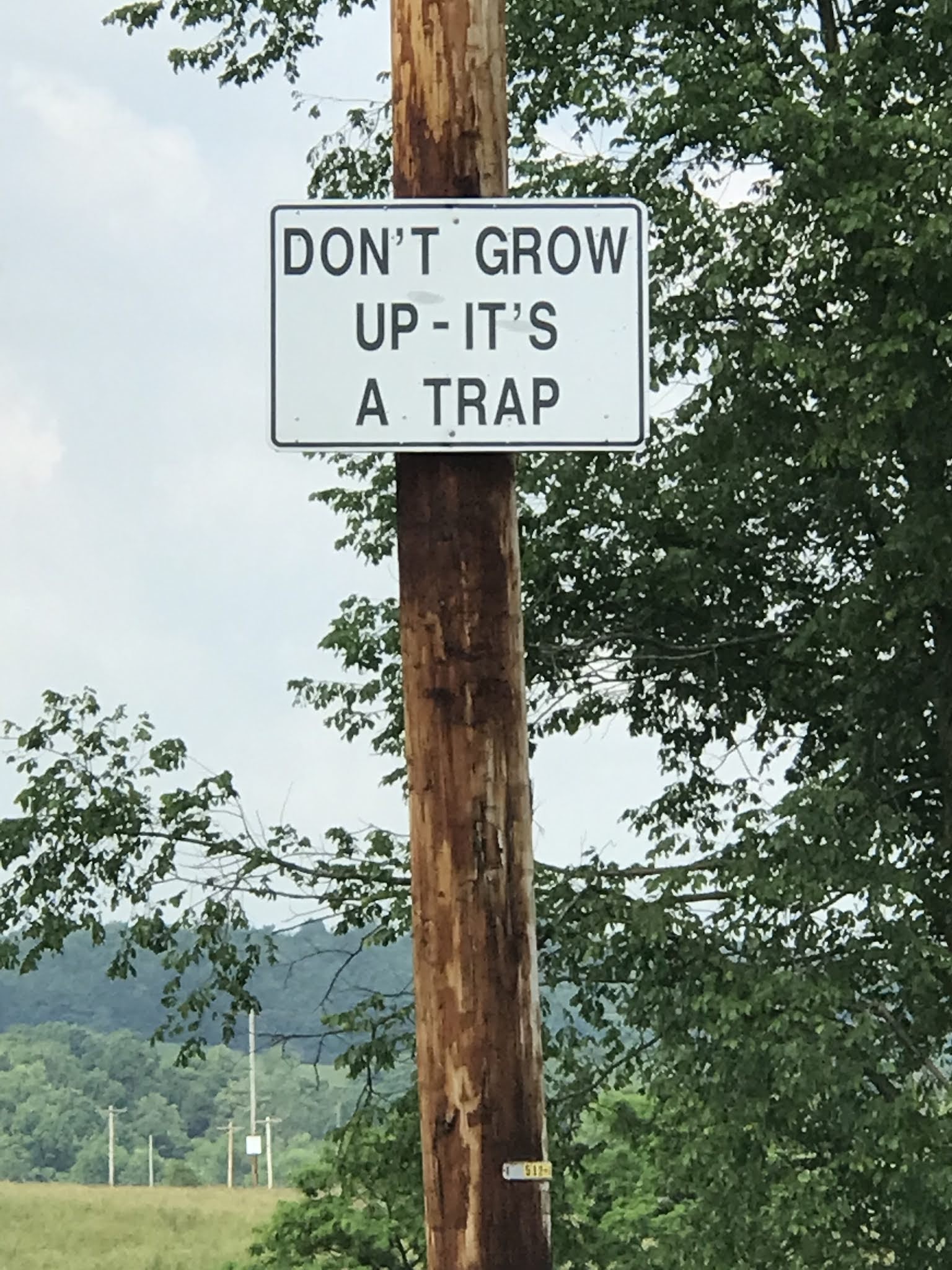
Day #2 brought us to my other of two favorite stops on the GeoTour... the
Dickinson Longhorn Ranch! What a hoot! The mile-long road leading into the property included a series of signs that cracked me up. Luckily it was a quiet Sunday morning as I asked SJ to stop at each sign for me. I'll share more tomorrow!
The cache was hidden at a beautifully maintained entrance to the market (unfortunately, closed when we arrived), but, peering through the gates, we could see peacocks in pens! And, of course, steers across the road! He look annoyed, doesn't he?
It's been hard narrowing down the selection of photos. After the ranch came Salem Cemetery, Willow Grove Mine memorial, which honored those lost in a mining disaster, and finally a waterfall at Newlin Falls Nature Trail.
We did it! 35 of 35 GeoTour caches complete! We earned our GeoTour souvenir, are entered into quarterly drawings and (I am) still waiting on my geocoin. This was a very fun geo-experience with ShelleyJean, and I'm looking forward to working on the
Smokey the Bear 75th Anniversary GeoTour next (we have one done so far!)
For Future Finders, words of advice for the Belmont County GeoTour: - The Microtel in St Clairsville was central, inexpensive, and clean
- You can do all 35 in one day, but start early.
- For food/hotel advice, contact the Belmont County Tourism Council via Facebook - they are very responsive
- For waypoints, read the logs. They may've been updated since then, but, at the time we did these, there were almost no parking waypoints for out-of-towners. Lack of local knowledge caused us some frustration.
- There is no passport. You are expected to either take selfies or write down the code words for emailing later.
- Have fun and happy caching!