After a six hour rest, the troops reunited and hit the road. Wisconsin is bright & shiny, and we still had Minnesota and Iowa in front of us. Yes, I'm on the road again with TaGeez and AstroEricJ.
 |
| Three new souvenirs |
Wisconsin
Madison is a beautiful town and seeing it in daylight has left quite the impression. I told TaGeez if we ever hit the lottery I would like to come back to the University of Wisconsin at Madison for school.
 |
| Lake Mendota |
 |
| Seen from the Howard Termin Lakeshore Path |
We took time for two Virtuals downtown - both with amazing views of Madison and the lake.
 |
| What the Honest Man Sees GC8406 |
 |
| Observation Point GC3850 |
 |
| View from the Observatory on Observation Drive |
Heading out of Madison and driving towards the Dells, we had no targeted caches for the day. Our goals were to make a find per county while primarily driving south along the Mississippi. We looked for highly-favorited, historic, Virtuals, webcams, and larges.
One of our first stops met several of these requirements. The Oshaukuta Marker Cache GCGQ6T is a Large Multi hidden in 2003. This was also a Wisconsin Lost Town - in fact, if you Google it, you get no results. The only remaining information you find about this village is the geocache, the marker, and a nearby road. We missed the turn the first time, but Eric quickly made a u-turn. All went well in the find until Eric, not realizing his true strength, broke the container* when attempting to replace the lid.
*Ok, I had to rib Eric. Actually, the container looks like it has weathered many extreme seasons and was brittle as a result. Needless to say, there are no nearby hardware stores, but Eric wrote a good note on the cache page.
We had to take an indirect route to the Wisconsin Dells (honestly, I'm embarrassed to admit that I'd never heard of them, but TaGeez and AstroEricJ were really well informed about them). The original route was blocked by an accident (we watched several ambulances and firetrucks turn onto the highway), but it was a lovely ride along the back roads. Winding country roads, passing farm after farm. Cornfields, low bluffs, and sunshine.
Near Camp Douglas and Mill Bluff State Park we started seeing these bare rock outcrops along the small mountain range that lined the road. Can you imagine the view up there?
As we headed to La Crosse, we descended from the mountainous area towards the Mississippi Plains. Again, both TaGeez and AstroEricJ were a fountain of knowledge about altitudes, river flows, and vegetation. This portion of the trip was better than any Geology class I've had.
Before crossing the river, this one sprung up on our radar, and we had to stop at Mom's TB Hotel GC3TWMZ. In someone's front yard, it was beautifully constructed. The drawer was on casters like a kitchen cabinet drawer and just rolled out smoothly. Beautifully maintained and worth the favorite points.
 |
| Mom's TB Hotel GC3TWMZ |
Minnesota
After a quick bite to eat, we crossed the Mississippi and made our first find:
Best Damn Fishing Cache GC2KG0N. Honestly, the boys made the find. I was too busy photographing myself on the pier.
 |
| Scrapcat and the Mississippi |
Our goal is to drive down the west side of the Mississippi until Davenport. Eric wanted a find in each county and for each DeLorme page for challenges. This is not as easy as it seems because the caches were few and far in between along this route. Plus, although we had mobile wi-fi, cell service was very spotty, and we were driving blind with no caches in this area saved to the GPSr.
Now, before you pass judgment, we left Michigan the day before with no plan or idea how far we'd make it outside of Chicago or which route we'd take. We had run some PQ's, but we were far outside Madison, Minneapolis and Davenport to cover every area. So, we were truly on an adventure. And, to save you waiting breathlessly to the end of this post, we managed to grab the qualifiers needed along the way.
 |
Cave of the Unknown GC2HAG9
It may be a DNF, but it was worth it for this photo |
Breathtaking views along the Mississippi.
 |
| TaGeez at the site of another DNF |
After what seemed like a short drive with bluffs on one side and lush floodplains on the other, we reached the Minnesota/Iowa border for another find and another souvenir.
 |
| AstroEricJ, scrapcat and TaGeez leaving town |
Iowa
At this point cell service was even spottier. This became really apparent as we passed an Artesian well on the side of the road. TaGeez spotted it, I started to babble excitedly, and Eric humored us by turning around. Luckily, he was able to get just enough signal to download the cache page and the logging requirements.
Ah, the requirements. Although unprepared, lucky for us the boys have smarticles and were resourceful enough to collect the answers using the tools at hand. Although the CO must've rolled his eyes at our creative answers, I won't post any spoilers here.
One interesting detail I can add (as seen on a sign nearby) is this spot was near the sight of Chief Blackhawk's capture in 1832 and the location of the last battle to end the Black Hawk War. This Earth cache was the first of three fascinating Earth caches on our trip, each with a very interesting history to share.
 |
| Blackhawk's Artesian Well GC22Y3F |
Back on the road we passed many interesting bridges over the Mississippi. We crossed this one to "acquire a new county" for the county geocache challenge. It was a lot of fun traveling with AstroEricJ and TaGeez on this road trip; Eric is a fount of knowledge and TaGeez truly has a love of the road.
Our next stop was in McGregor. What a fascinating place! The whole town reminded you of a wild west town but in the bluffs and not on the priarie. Board walks, apothecary shops, an old fashioned bank and town center. This was also the sight of a very cool Earth cache.
 |
| Keeping Cool in McGregor GC1EGHW |
With little flat land, the townsfolk built where they could. Residents of McGregor built houses between the river and bluffs, often leaving no room for a backyard. Instead, in the days before refrigeration, they built cellars right into the bedrock.
 |
| Cellars cut out in the walls |
An ode to my friend, Lauri. Lauri loves signs shaped to represent the function of the building. In this instance, a mortar and pestle for the apothecary shop. Although I took pictures all along this trip for her, most were from a moving vehicle and pretty horrible. We did spot an
upright 18-wheeler truck at the truck stop, a tractor at the John Deere lot, an oversized ice cream cone, giant skis, a giant baseball hat outside the sports equipment shop, a giant dinosaur outside a playland, and a herd of elephants outside the Kalahari entrance.
 |
| McGregor Apothecary Sign - an ode to my friend Lauri |
The sun is starting to set, and we know we'll need to turn home soon. TaGeez, a saint in the back seat for almost 2 solid days, needed a pit stop near the town of Dyersville. Somehow, while perusing his phone in Hardees, he realized we were a few miles from the "Original Field of Dreams" (where they filmed the 1988 movie with Kevin Costner). He's a HUGE fan, and, luckily, we still had some wiggle room in our schedule.
 |
| I found the cache - it was near my butt GC359Z4 |
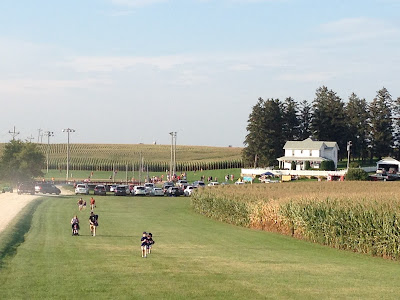 |
| If you build it, they will come... Lots of fans here |
AstroEricJ spotted the
Hurstville Lime Kilns GC1AV4A Earth cache on the map, and I'm glad we turned in. It was an interesting combination of geology and history. The kilns were in operation from 1870 - 1930, with nearby Hurstville truly a company town. Built around the 2 Hurst mansions, there was a single-men's boarding room, a company store, and a post office. The sign says the men were treated well; in addition to an hourly wage, they were given a company home, a garden and a pasture to graze a cow.
 |
| The setting sun lit the limestone on fire |
Last stop before heading home? A webcam in Davenport. It's amazing you could see us through the buggage! Oh, so many flying critters!
Heading Home
Now, one little truth about AstroEricJ. Don't let that positive exterior fool you. Deep inside he's a wild man, a risk taker. He's not pulling into a gas station unless he absolutely has to. 2 miles to empty while on a quiet, rural highway in the middle of nowhere? What's to worry? He explained his theory about "those that worry about running out of gas" and "those that don't". To summarize, what's the big deal? You run out of gas you walk to get more! He never did answer my question about how many times he's run out of gas in his lifetime :) This was not the lowest he let the tank go before refilling. He has this down to a science.
As we headed East towards home, we did manage to stop at each Illinois and Indiana county along the way. Most were park-n-grabs, but we did manage one last Virtual on the trip. The 300 year-old pole in the town of Morris marks the grave of Chief Nucquette. We, of course, had to stop.
 |
| Nucquette's Rest GC8EF6 |
Forty seven hours after our trip began (and with only six hours of sleep), we pulled into the driveway at 5:30am - Happy Labor Day! I hope yours was enjoyable - we slept through most of ours!
+*+*+*+*+*+*+*+*+*+*+*+*+*+*+*+*+*+*+*+*+*+*+*+*+*+*+*+*+*+*+
SOMETIMES IT IS ABOUT THE NUMBERS, TOO!
3 good friends on a fun Labor Day adventure
1300 miles for 59 geocaches in 33 counties
6 states = 3 new state souvenirs
1 JASMER completion
2 Webcam caches
3 Earth caches
7 Virtuals


