Showing posts with label Virginia. Show all posts

Monday, October 24, 2016

Outer Bank Adventure: The Webcams

As if 2,500 photos weren't enough, TaGeez and I posed for 5 special cameras on our trip.


Webcam Cache

These are geocaches that use existing web cameras that monitor various areas like parks or business complexes. The idea is to get yourself in front of the camera and save a screen capture from the website where the camera is displayed in order to log a find.
There were actually 8 within the vicinity but one was a little too far off the path, one was down and the final wasn't available on the weekends. The five remaining made for an interesting adventure.

Greensboro, North Carolina

This was a great camera as it updated real time and was live. Apparently, we were lucky to seek it out after the construction nearby had been completed.


After finding it, we decided it was a little late to drive to Raleigh for dinner so we sought sustenance nearby. How cool was this? Natty Greene's brewpub is located in a former Confederate Arms Factory! We had an amazing (and relaxing) dinner of Cajun pork over a Butternut squash-onion-pork belly hash. 


Apex, North Carolina

This webcam might possibly be the most expensive cache for us ever. Driving late at night from Raleigh to Wilmington, we followed the GPS towards Apex. As we were changing highways we saw the toll notice, and pulled out our wallets. It wasn't until we were committed that we realized this toll road is either paid by EZPass or "Bill by Mail". DOH! And we were in a rental car. Either way I'm not looking forward to that administrative fee.


TO LATE TIP: After that, we pulled over and changed the settings on our NUVI. From this point forward the navigation system will prompt us prior to selecting a toll route. The NUVI will offer an alternate route - in Maryland, the alternates saved us money but only added minutes to our drive time.


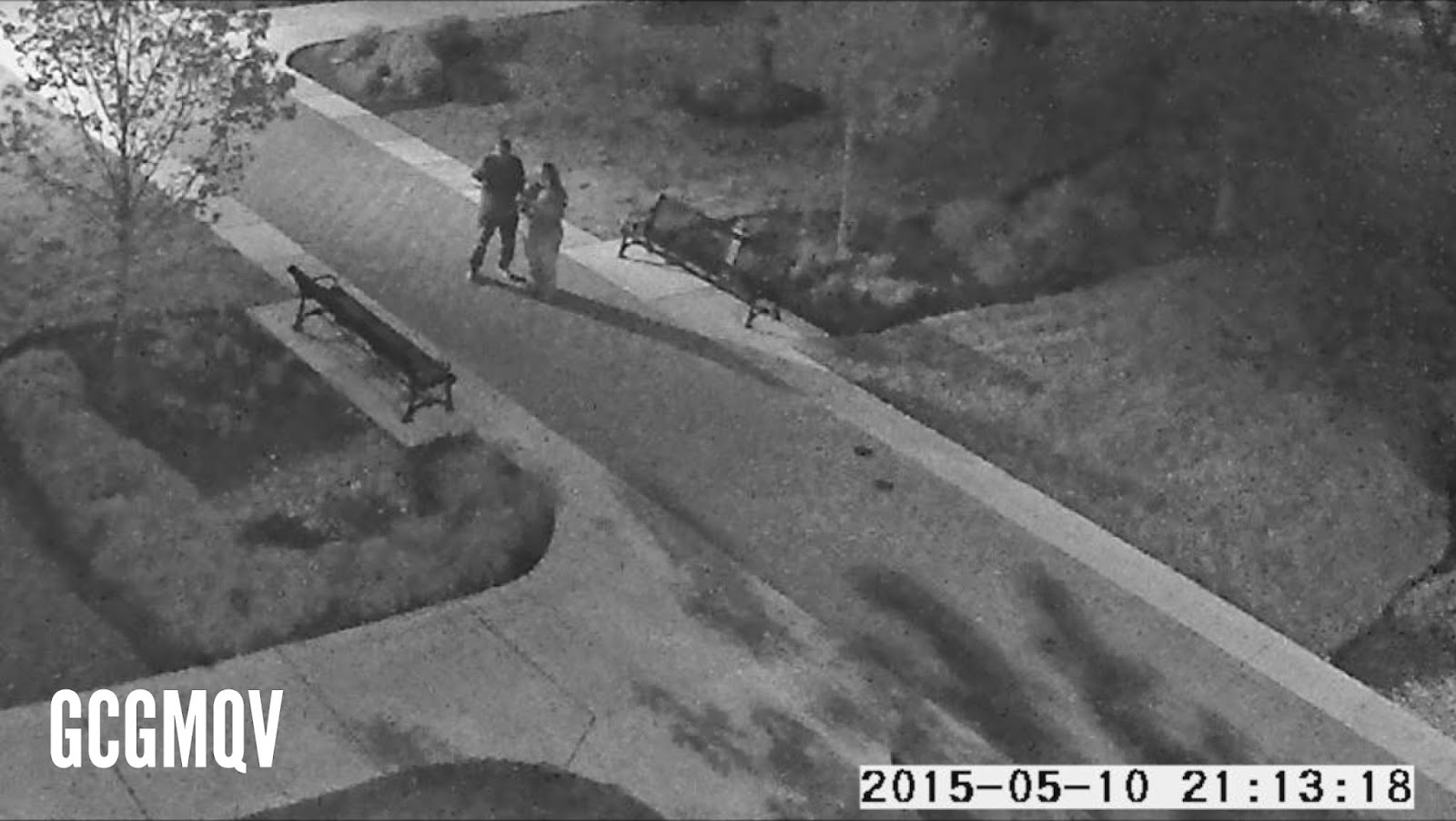
Kill Devil Hill, North Carolina

This one we tested before we left home. Imagine our disappointment when we arrived and discovered the Avalon Pier webcam hadn't updated in 5 days! We approached the man at the dock, hoping he could reset the camera since there was no contact information on the site. He said he couldn't reset it as Hurricane Matthew had wiped out their internet with no ETA for repair.

Oh no! What to do? We scoured the internet and discovered there was an alternate webcam covering the Avalon Pier parking lot! 


Unfortunately, it panned both sides of the parking lot at odd intervals, and we couldn't seem to be in the frame at the same time. We each covered a different part of the lot and was able to take a photo of the other. We both used the same website, but look how different the photos came out!


The pier administrator did allow us to go out on the pier and take a selfie, too. Wow! Was that thing rickety!


Cape Hatteras, North Carolina

Driving south from Avalon Pier, we entered the Hatteras National Seashore. Lovely drive with lighthouses, sandy dunes, and yet another webcam! This one was tricky as our first attempts came out so dark - there was a large cloud blocking the sun so you could barely see us in the images. After driving further south and then turning around, we mad a second stop with this one much more successful. 


Looks almost like a watercolor, doesn't it? Several people had claimed the camera was down recently - they were trying to use the outdated webcam URL in the cache description, but I found better links in the recent logs.  Preparation is the key: this one was a little too far not to nab the first time.


Richmond, Virginia

So far each webcam has been some kind of adventure so we decided, upon arriving in Richmond, to go for this last one before heading over to Hollywood Cemetery. Something should've clued us in when we approached the campus gate and had to drive past a line of police officers.

We heard drums playing. We saw parking lots manned by volunteers. We wound our way to "one of the last six parking spots on campus!" We pulled in across from a group of tailgaters. What the heck? Oh, no! We stopped for this webcam during Homecoming!


Congratulations to the University of Richmond Spiders for beating Villanova during your Homecoming! Woot! Woot! With everyone distracted by pregame, we had the quad to ourselves for this final webcam find!


WEBCAM SUGGESTIONS


  • Locate the links before the trip. I saved mine in an Evernote file and also added a shortcut to each on my iPhone screen. In my Evernote file, I will note special instructions like "Park closes at dusk", "campus webcam not available on weekends", "hold your GPS aloft like Thor". 
  • If the links from the cache description do not work, scroll through recent logs. We have been able to find mobile-friendly URLs in the logs.
  • Make sure the webcams are viewable on your phone. If it doesn't work on mine, TaGeez will try it on his Android. His phone has several alternate browsers and can typically find one to work. We've even downloaded special apps if the webcam requires JAVA.
  • To save frustration, determine how long it takes for the camera to refresh. Some are live feeds and some can refresh every 15 minutes. One mentioned it refreshed hourly after 9 pm. 
  • Have a back-up plan. On each trip we've sent the links to a friend back home in case we're in an area with low cellular capabilities.
  • Tap your local geocaching Facebook group when in a pinch. We've received urgent pleas on the Southeastern Michigan Geocaching Facebook group for help.
  • Read the recent logs to make sure the camera is working. If not, check with the CO to confirm if selfies are allowed. We carry a mini tripod in our caching bag and will set it up on the car trunk.
  • Clothing choices can make a difference. View the live image beforehand and determine the best color choices so you'll stand out in the picture.  
  • Stand in open spots or under street lights. If it's night and there is no bright light about, bring your own. 


Monday, May 25, 2015

GJJ: Charlotte to Detroit

As I told my family, this was more of a driving adventure than a geocaching road trip.  Yes, we did a TON of geocaching and managed to pickup at least 3 caches in every state we crossed paths with, but we stopped to smell the roses, too.  Nothing more fascinating than scenic mountain views and roadside America!

As we took I-75 down, we elected to return via I-77.  It was hundreds of miles of roads and mountains.


Ok, we couldn't pass it up.  In upper North Carolina is the grave site of the original Siamese twins, Chang and Eng.

The Bunker Brothers GCF338
The cache page gave a fascinating history of their arrival to the region, their marriage and 21 kids (their descendants number in the 1,500's!), the shocking demise and burial.  They have an amazing mountain view from their final resting place.


And just a few miles up the road is another site of historical significance.... do you recognize it?


As a military wife passing the highway signs for Mount Airy (Mayberry, RFD), I always wanted to stop, but there was never time.  TaGeez was more than game to pull of and explore the little town.

Mayberry Reflection GCJF9C
Unfortunately, it was Sunday and EVERYTHING is closed except the packed churches nearby.  We strolled through town, grabbed a few caches and visited the historic replicas of Mayberry's garage, county courthouse and Floyd's barber shop.


I have to say this is one of my favorite pictures of us EVER.  Taken at the Virginia rest stop, Virginia really is for lovers!


Have you ever noticed this from the freeway?  This is the Shot Tower of Jackson Ferry.  Now that it's been pointed out to me, it's very noticeable from the highway.  It was used to make lead shot in the 1800's, and it has several very interesting signs out front explaining the history and manufacturing process.

Old Tower GCG1RB
What I found more interesting was the view from the hill.  Beautiful!


Well, we did stop for a cache so we pulled off to grab it.  It was the first time we found one literally in the mountain!


Wildflowers lined the highway from Charlotte through Columbus.  This had special meaning to me as I was driving along the mid-Atlantic roadways.

This leg of the journey was on Sunday - Mother's Day.  And 22 years ago this very week, I was also driving these exact roads from Carolina to home.  My mother had passed, and I was going to see her for the very last time.  Every time I remember that trip two decades ago I recall how sunny the day was (unfathomable blue skies) and the hundreds of miles of wildflowers in the median.  Who would've thought all these years later, during this same week, on Mother's Day, I would be on these exact roads, heading in the same direction? Blue skies.  Wildflowers.

Slightly Scenic LPC GC4J28R
And don't forget the scents!  Most amazing floral breezes!
Still feeling the effects of my trip down memory lane and witnessing a 3-car fatal accident on I-77, we decided to stop at another highly-favorited cache for some fresh air. This is (as the sign professes) the smallest church in Wythesville and one of the smallest in the country.  The inside contained 3 pews and nothing else.

Seek and You Shall Find GC36192
At first, we were confused.  The coordinates took us towards the back corner, but there were only rocks. What's the big deal?  After a moment's contemplation, the realization hit home.  The cache container was not outside the church, it WAS the church!

With caution, we opened the door and stepped in.  And there was the log!


I wish we had more time to explore all the other novelties along the roadway, but time was drawing short. We had several must-see stops still, so we made some miles on the highway.  I had totally forgotten that you must drive through (not one but two) mountains along this route!  Too cool! 


Leaving Virginia, we arrived in West Virginia around dinner time.  Although it had been my hope to spend more time in the state capital, reaching home by midnight was our priority. TaGeez humored me, so we grabbed this special cache in Charleston.  Regretfully, we had to skip the webcam as the cache page absolutely forbade visiting the campus on the weekends.

In the Basement of the Library GC36G4CZ
After Charleston, our route took a new path towards Hocking Hills, OH.  After crossing a rather impressive aqua-colored bridge, we finally had our first rain of the trip.  Weirdest 5-minute deluge I've ever experienced because there was not a cloud around and the sky was vivid blue.  We were rewarded with a double rainbow for our troubles.

Double Rainbow!
The drive from the Hocking Hills area to Columbus was probably the least thrilling of the trip (construction, tiny towns, rural amenities), but we had one more stop on our agenda.  The Columbus webcam on the OSU campus was the only functioning webcam on the entire trip!  And we even took a pretty impressive picture in the dark!

March to the (Missing) Arch GCGMQV
We arrived home around 1 a.m.  Exhausted.  Exhilarated.  And already plotting our next adventure.

+*+*+*+*+*+*+*+*+*+*+*+*+*+*+*+*+

Sometimes it CAN be about the numbers, but it also helps if it's about the experiences, too.
  • 2,000 miles across 10 states in 4 days
  • 8 new state souvenirs: KY, TN, AL, GA, SC, NC, VA, and WV
  • 61 caches including 2 JASMER fillers
  • 4 webcams, 20 Virtuals, 2 lending libraries and 1 Earth Cache.
  • Major, memorable stops include Newport (KY), Lookout Mountain (TN), Stone Mountain (GA), Oakland Cemetery (Atlanta), and Mount Airy (NC).
  • Roadside curiosities included: Many unique bridges, a GIANT bell, multiple riverboats, a striped horse, the Great Locomotive Chase, 1970's gas pumps, a dead armadillo, the deep red clay of the Appalachians, a confederate Bas-relief, the White House, a large silver bird, a baseball diamond that isn't, an Olympic 'torch', and the memorable cemeteries (Revolutionary War, forgotten Confederate, the National Cemetery and Oakland Cemetery).

Saturday, May 16, 2015

Georgia JASMER Journey: Eight New Shiny Souvenirs

What an adventure!  2,000 miles through 10 states in 4 days!

TaGeez and I were getting restless.  With half a year practically over and some events on our horizon that may clip our wings, we needed to get out.  Where do you go on a long weekend?  Why.....

MI > OH > KY > TN > AL > GA > SC > NC > VA > WV > OH > MI

Yes, tired but satisfied!


Along the way we grabbed eight virtual souvenirs.  Pretty, eh?


When asked, we admitted we did this roadtrip for two special JASMER caches: Beaver Cache (the beavers have moved on) GC1D June 2000 and Modoc Stash GCF4 December 2000.  Because what would be cooler than finishing off your JASMER grid on the 15th Anniversary of Geocaching? Two more down and just two more to go! And the last two?  Well, they're practically in our backyard!

This cache was the biggie, and I had been watching it for weeks.  In a residential area, the hardest part of this find was dealing with the rush hour traffic along the way.  The owner had parking requirements and, following the fence around the tennis court, you reach a pretty little pond and the cache (about 300 feet from parking). The container above is housed in a larger, white container, and it floats during a rainstorm.  No beavers but plenty of mosquitoes at dusk.


This one had us worried.  Unlike the other oldie, this one was a trek, and we were running out of time.  Modoc Stash is located in Sumter National Forest just across the western border of South Carolina. We were delayed by interesting Atlanta Virtuals, 41 miles of construction, an attack by a construction barrel, a flat tire near Conyers, a closed highway in Appleton, and a tailgating Sheriff near the border.
We arrived at dusk (taking all proper precautions - we were both Scouts) and set off quickly. It's "only a mile walk out there" but it involved hiking trails hugging the sides of small mountains and hills, snake-like switchbacks and 3 river crossings each way!  Even that late at night, the temperature was in the 80's and the humidity felt like a wet blanket.  But we did it! It's this type of cache that reinforces why we do this crazy obsession - all that was missing was the Indiana Jones theme music!
Thank you to all the prior finders who warned us to stay on the trail.  There's no way bushwhacking would've cut down the time. We returned to the parking lot at 8:32 pm, and, within 15 minutes, the sun was gone and we were heading to North Carolina in pitch darkness.
Over the next several posts I'll share the amazing Virtuals, webcams, and special caches that also crossed our paths!