Monday, May 18, 2015

GJJ: Knoxville to Atlanta

Big day on the adventure!  We tour Virtuals, pose for webcams and even grab a Jasmer. But it was not all geocaching - we saw some amazing sites off Lookout Mountain in Chattanooga and Stone Mountain in Atlanta, too.

Note: There are no spoiler pictures for the Virtuals.  Just a bunch of selfies for our qualifying logs.  
And not even good selfies - it was hot!  Even at 7:30 at night it was over 90 degrees and sticky!

Our first full morning found us packing and having breakfast at the seriously unfabulous Knoxville Clarion Inn.  But that's OK because we knew we had some miles to go and many, many, many stops along the way. The town of Cleveland, TN was a two-fer: a webcam and a virtual. Not much else.
The Village Green Webcam Cache GCHFG6 - it was down. Bummer.
This is a tiny Mausoleum in the middle of the town housing the Craigsmile family, a tragic story about a little girl killed in a train accident and the sad story of her remaining family.  Per the cache page:
Today, if you visit the mausoleum, you will notice red streaks the color of blood appear on it. The stories say that the bloody stains first began to appear on the Craigmiles mausoleum after Nina was interred there. With the death of each family member, the stains grew darker and more noticeable. Some of the locals began to believe that the marks were blood, coming from the stone itself, in response to the tragedies suffered by the family.
The Blood Stained Mausoleum GCKNVT
After Cleveland, we headed down to downtown Chattanooga for another series of Virtuals. First stop is a long-forgotten Confederate Cemetery that housed the remains of 155 unknown soldiers who died in hostpital during Bragg's Kentucky campaign.

The Unknown GC518E
Afterwards, we visited the Chattanooga National Cemetery.  Beautiful, isn't it?  


Here is a fascinating story.  Look at the train atop the monument.  Here's a snippet of the story:
The Great Locomotive Chase was a military raid that occurred April 12, 1862, in northern Georgia during the American Civil War. Volunteers from the Union Army commandeered a train and took it northward toward Chattanooga, Tennessee, doing as much damage as possible to the vital Western and Atlantic Railroad (W&A) line from Atlanta to Chattanooga as they went. They were pursued by Confederate forces at first on foot, and later on a succession of locomotives. 
Because the Union men had cut the telegraph wires, the Confederates could not send warnings ahead to forces along the railway. Confederates eventually captured the raiders and executed some quickly as spies; some others were able to flee. Some of the raiders were the first to be awarded the Medal of Honor by the US Congress for their actions.
 The next day we visited Oakland Cemetery where the captured had been interred, hung and buried in an unmarked grave (they were eventually reburied here).  In Oakland Cemetery (somewhere... we ran out of time plus it was so blasted hot!) is a headstone for the Confederate conductor of the train.

The Great Chase #3 GC5148
 In the background, you can see Lookout Mountain looming.

Rest in Peace GC4E66
 But before heading up that mountain, another attempt at a webcam.  Again, not working.

I See You! GCPB7G
Lookout Mountain was the scene of the 'Last Battle of the Cherokees' during the Nickajack Expedition, which took place in the 18th century, as well as the November 24, 1863 Battle of Lookout Mountain during the American Civil War. [Wikipedia]

They have an Incline Railway

The Most Amazing Mile GCMFYC
A fascinating exhibit detailing movement of the Civil War Battleground (played out overlooking an amazing view).  The best part is when JimLob65 told me the history of the battle on this mountain - I have no idea how the Yankees managed to gather the resolve to ascend, and I am amazed at their success.


And, of course, it's now a tourist destination.  


Unfortunately, we dallied in Chattanooga longer than intended so we moved onto Atlanta.. via Alabama. Thanks to Ratspazum who reminded us that a slight detour of a few miles would add another state to our stats.

The visitor center was absolutely beautiful, lined with the state flower.  But outside of that, it was terribly poor and very sparse.  

Our first Alabama cache: Barn Art GC3W3RJ
As per our regular routine, we stopped in every state at the gas station. We discovered that the drive from Detroit to Atlanta (and South Carolina to West Virginia) was all uphill.  Thankfully, gas prices were half as much as last year so it wasn't as painful going twice over our budgets.  We averaged from $2.22/gallon to $2.57/gallon.  This stop threw us for a loop.  As we pulled up, I asked TaGeez, "Do you know how to run these?"  Luckily he's a jack of all trades and a keeper of useless knowledge.

I sent this picture to my Dad, laughing at our Alabama 
experience.  He promptly told my brother (who lent us
his car for this adventure).  It wasn't long before I receive
the text from him.  Uh oh! Busted! He said we're nuts!
After driving up one side of an Alabama mountain range and down the other (passing a dead armadillo in the road (I've never seen a real one before! He looked like he was napping), we eventually made it into Georgia.

The Chieftains Trail - Chieftains Museum GCG00X
By now things were running very behind - after dinner - and we hadn't accomplished any of our Atlanta goals.  Although it was a beautiful drive into Atlanta, we needed to keep going through and head East.  There was no way we could reach Atlanta and NOT get our target JASMER cache: Beaver Cache (the beavers have left) GC1D hidden June 3, 2000.

Fearful that the neighbors would have issues if we attempted this past dark, we skipped the hotel and dealt with Atlanta rush hour traffic to reach the small residential community.  These people have money!  Pulling into the designated parking near the tennis courts and swimming pool, we headed around the courts and towards the pretty little pond (lined with oh so many No Trespassing signs!).  Walking 300 feet, brushing off mosquitoes and watching the sun dip down, we found our prize.
We did it! Beaver Cache GC1D
The container was a little wet so we cleaned it out, deposited some Michigan path tags and dropped TaGeez's NCEES trackable. Funny epilogue on this trackable.  We drove it all the way down from Michigan to release it in Georgia only to have the next finder drive it all the way back to Michigan again!  It's in the U.P.!

After discussing our options, TaGeez and I decided we should stop at Stone Mountain on the way to our hotel.  We figured we'd have no time in the morning, and we had hoped it would be a little cooler than midday.  We were correct about the former but not the latter - 91 degrees after dark!


The beginning of the famed Appalachian trail, Stone Mountain is equal parts state park and tourist mecca. It is famous for it's Confederate bas-relief (and light show) on the North wall of the mountain.  It took three artists 56 years to complete - the first artist, Gutzom Borgium, went on to create Mount Rushmore.
The largest high relief sculpture in the world, the Confederate Memorial Carving, depicts three Confederate heroes of the Civil War, President Jefferson Davis and Generals Robert E. Lee and Thomas J. "Stonewall" Jackson. 
The entire carved surface measures three-acres, larger than a football field and Mount Rushmore. The carving of the three men towers 400 feet above the ground, measures 90 by 190 feet, and is recessed 42 feet into the mountain. The deepest point of the carving is at Lee's elbow, which is 12 feet to the mountain's surface. 
Now, before you ask, no, we didn't get the Tour of Stone Mountain (June 2000) Multicache.  There was too many stages, too much climbing and we were running out of time.  We did, however, grab a few more Virtuals before riding into the sunset.

Appalachian sunset
Our next adventure will feature a White House, a giant silver bird, a home run king, a Confederate Lion, Oakland cemetery and the trials of reaching one of the oldest caches in the area: Modoc Stash GCF4 (December 2000).

Sunday, May 17, 2015

GJJ: Detroit to Knoxville

Our first day took us from Detroit to Knoxville, TN.  Along they way, on a whim, we stopped off in the Newport/Covington area of Kentucky.  What a wonderful little town on the river.  We saw factories converted into breweries and little outdoor eateries intermingled in the neighborhoods.  Definitely worth a trip back.

Our first Kentucky cache was the Virtual "Newport KY" World Peace Bell GC653C.  Another example of the fascinating places geocaching takes you.


It was a nice plaza that contained a Visitor Center, a 911 Memorial, a firefighter memorial and a traditional geocache.


This was too sweet to pass up so we decided to hang around longer than intended. Right around the corner was a historic courthouse and a trail of traditional caches so we moseyed along, reading markers.  Eventually we made it to the riverfront and Riverboat Row.

Ohio skyline viewed from Kentucky
 See the riverboats behind TaGeez?  And the bridge?  This bridge was one of several that connected Ohio and Kentucky at this point - each one a different color and style.

TaGeez signing the log. We also completed a nice Earth Cache here:
Confluence of Ohio and Licking Rivers GC1YGC4

AFK to Riverfront of Newport KY GC4PZEZ

One of the many beautiful bridges, leading to Ohio

Mutter Gottes Little Free Library GC55RKP
One of 2 caches found in the little libraries on our journey
Finally, however, the sun started to set and we had a few miles to go before our first of four webcams on the trip. No good posing for a webcam if you can't see us.  Unfortunately, only the last webcam work so we practiced a lot of selfies on this trip!  This one was taken using my mini-Gorilla tripod resting on the trunk of the car.

Weather or Not Webcam GCG52C

After the webcam, darkness arrived quickly.  We did have a chance to glimpse some amazing gates leading up to some immense houses along this Kentucky road.  You can tell by the names of the roads and highways that we were in horse country.


Next time: Knoxville to Atlanta.  The Yankees have arrived!

What is the JASMER Grid?

Fair, enough.  I've been babbling about it for a year now, and I was asked to define it.


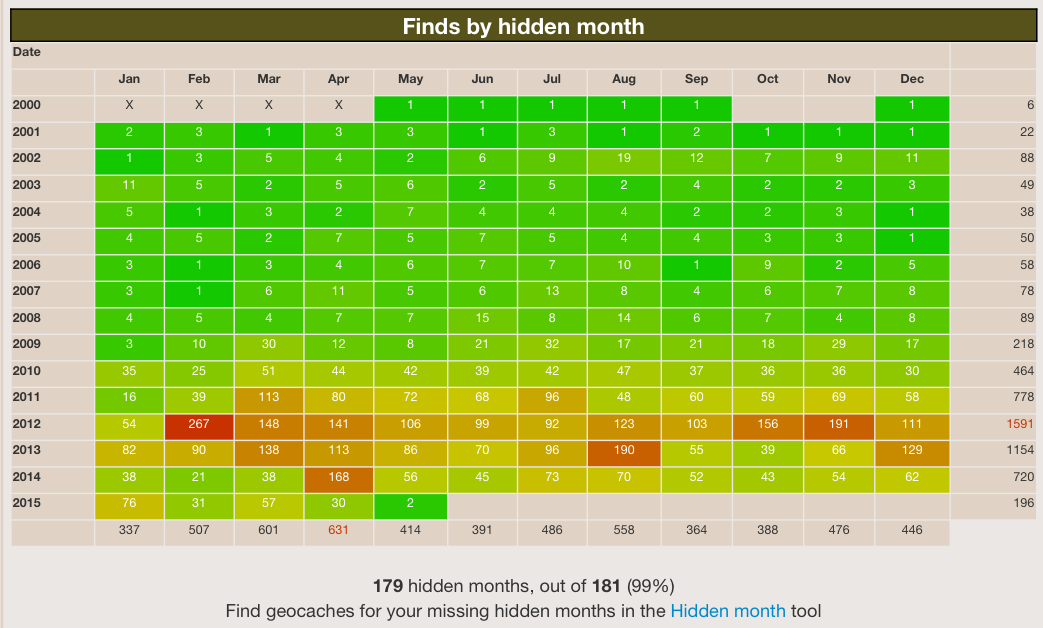
The JASMER grid is your Finds by Hidden Month grid (easily accessible via project-gc.com or by using a GSAK macro).  The challenge is to find at least 1 cache hidden in each month since geocaching started. This will get harder and harder as older caches are being archived.

In the last year, we grabbed our May, July & August, and September 2000 caches. On our recent Georgia adventure, we found our June and December 2000 caches!  Just two more to go and both of them are in nearby Indiana!  I feel a Fall road trip coming on!

Saturday, May 16, 2015

Georgia JASMER Journey: Eight New Shiny Souvenirs

What an adventure!  2,000 miles through 10 states in 4 days!

TaGeez and I were getting restless.  With half a year practically over and some events on our horizon that may clip our wings, we needed to get out.  Where do you go on a long weekend?  Why.....

MI > OH > KY > TN > AL > GA > SC > NC > VA > WV > OH > MI

Yes, tired but satisfied!


Along the way we grabbed eight virtual souvenirs.  Pretty, eh?


When asked, we admitted we did this roadtrip for two special JASMER caches: Beaver Cache (the beavers have moved on) GC1D June 2000 and Modoc Stash GCF4 December 2000.  Because what would be cooler than finishing off your JASMER grid on the 15th Anniversary of Geocaching? Two more down and just two more to go! And the last two?  Well, they're practically in our backyard!

This cache was the biggie, and I had been watching it for weeks.  In a residential area, the hardest part of this find was dealing with the rush hour traffic along the way.  The owner had parking requirements and, following the fence around the tennis court, you reach a pretty little pond and the cache (about 300 feet from parking). The container above is housed in a larger, white container, and it floats during a rainstorm.  No beavers but plenty of mosquitoes at dusk.


This one had us worried.  Unlike the other oldie, this one was a trek, and we were running out of time.  Modoc Stash is located in Sumter National Forest just across the western border of South Carolina. We were delayed by interesting Atlanta Virtuals, 41 miles of construction, an attack by a construction barrel, a flat tire near Conyers, a closed highway in Appleton, and a tailgating Sheriff near the border.
We arrived at dusk (taking all proper precautions - we were both Scouts) and set off quickly. It's "only a mile walk out there" but it involved hiking trails hugging the sides of small mountains and hills, snake-like switchbacks and 3 river crossings each way!  Even that late at night, the temperature was in the 80's and the humidity felt like a wet blanket.  But we did it! It's this type of cache that reinforces why we do this crazy obsession - all that was missing was the Indiana Jones theme music!
Thank you to all the prior finders who warned us to stay on the trail.  There's no way bushwhacking would've cut down the time. We returned to the parking lot at 8:32 pm, and, within 15 minutes, the sun was gone and we were heading to North Carolina in pitch darkness.
Over the next several posts I'll share the amazing Virtuals, webcams, and special caches that also crossed our paths!

Thursday, May 14, 2015

Heartbroken in my GeoSphere World!

Any GeoSphere users here?

I'm a GeoSphere (iPhone geocaching app) fanatic. I really think this app is a major factor in my 3-year cache-a-day streak. Imagine my heartbreak when I tried to upload logs two nights ago and started getting intermittent "connection error" messages.

When I clicked on my Online Profile, my stats weren't updating. I unlinked from Groundspeak and re-authenticated. I uninstalled the app and re-installed. Now my profile information is completely blank! Anytime I try to update, more connection errors (left image)! No quick access to my Lists or Pocket Queries - ugh!

And if I try to use the Caches Online feature (right image), I get a new message! "A minimum of 1 and a maximum of 6 users are allowed for the NotFoundByUser filter". No caching on the fly!

Keep in mind I've tried this on my own wifi, work wifi and using cellular data.

I checked the GeoSphere forums. The developer isn't active and hasn't released an update in a year and a half. Apparently, this is a known issue since 2013! Most of the forum posts say they think it's an API connectivity issue with Groundspeak and nobody has a solution. Some have come back and said it's working now.

Not me.

My iPhone 5 running IOS 8.3 and GeoSphere 3.2 is broken. It's like a punch in my geocaching gut. 


UPDATE: Good news!  It's working again! After several days of repeated attempts, voila!  Went on the Forum and found I wasn't alone so we think it had to do with recent Groundspeak API changes.  Relief! In the meantime, I tested several other iPhone geocaching apps.... brrrrr!

Sunday, May 3, 2015

Challenges of Challenge Caches

(sigh) Maybe this Challenge cache moratorium will be a good thing. Another year with new finders exclaiming in their logs on my challenge caches, "Yeah! My first cache!" 

Two more today - one a repeat offender who I've emailed several times and one with no email verified. Hurts my heart to delete their first logs, but it's not fair to those who qualified. 😞

I finally changed my I Got The Bug 2-1-0 Challenge to Premium. ((sad))

Saturday, May 2, 2015

Projecting Good Puzzle Vibes!

Projection puzzles were hard for me when I started geocaching. Probably because the first ones attempted were Rattrak's, where you had to project over 1,000 ft but my GPSr unit could only do up to 1,000 feet.

Being a "tool girl" (and someone who more often caches using my phone versus a GPSr), I found several alternative solve methods that saved my sanity. I use them depending on which I have immediate access to.

* GeoSphere - In my IOS app, I can Edit > Edit Options > Edit Location to access the coordinates. If you click the sprocket, one of your options is Project Location. TaGeez uses the GCC Calculator for Android.

* If I'm at a computer, I use GSAK. Click the Waypoint menu option and select Project. You can find further instructions in this forum post. 


* Finally, if neither is available to me for some reason, there is the Coordinate Projection tool found at the Geocaching Toolbox.

In any method, it has taken the anxiety out of projections and opened up another puzzle type for me. Need proof? This morning TaGeez and I shared FTF on the new Puzzle Solving 101 - Projections cache at 6:38 am! Dressed in pajamas, flip flops and a raincoat, we solved and then found it while half asleep!